The Conor Pass is one of those roads you remember for the drive itself, not for a single sight at the end of it. We drove it on our 2026 Ireland road trip, heading from Fermoyle Beach on Brandon Bay over the mountains towards Dingle. In this guide we cover where the pass is, what the R560 is actually like to drive, where you can stop for the views, the vehicle restrictions every van and campervan driver needs to know, and whether the Conor Pass deserves a place on your Dingle Peninsula itinerary.
Conor Pass at a glance
- RoadR560, Dingle Peninsula, Co. Kerry
- ConnectsDingle town and Kilmore Cross (for Cloghane/Brandon and Castlegregory)
- Summit heightAbout 456 m, often called Ireland’s highest drivable pass
- Pass sectionAbout 12 km, narrow and twisty, partly single-lane
- Vehicle limitsMax. 2 tonnes and 7.2 m listed; over 2 t not permitted north-east of the summit
- StopsSmall summit car park and the waterfall lay-by on the north side
- CostFree, no toll
- FacilitiesNone on the pass
What Is the Conor Pass?
The Conor Pass (An Chonair in Irish) is the mountain crossing of the R560 on the Dingle Peninsula in County Kerry. The pass section runs for about 12 km between Dingle town in the south and Kilmore Cross in the north, where the roads fork towards Cloghane and Brandon or Castlegregory. The road climbs between the peaks of Beenduff and Slievanea, and at around 456 metres the summit is often described as the highest mountain pass in Ireland you can drive (Wikipedia).
For most visitors it is the scenic shortcut between Dingle and the north side of the peninsula. Instead of following the coast, you go straight over the mountains, through a landscape shaped by glaciers: corrie lakes, bare rock and a wide U-shaped valley below the road.

Driving the Conor Pass: What to Expect

The road itself
The R560 over the Conor Pass is narrow, twisty and in places only wide enough for one car, even though traffic runs in both directions. When you meet an oncoming vehicle on a narrow stretch, one of you pulls into a passing bay or reverses to the last wider section (Wikipedia). Signs along the road show how far it is to the next passing bay, which helps you judge when to wait. On the northern side, the stretch just below the summit is the tightest, with lay-bys where you are asked to pull in for oncoming traffic.
Our drive from Brandon Bay
We drove the pass from north to south, coming from Fermoyle Beach on Brandon Bay towards Dingle. From that side, the road leaves the farmland around the bay and climbs into an increasingly bare mountain valley, with the waterfall lay-by and Peddler’s Lake on the way up to the summit. We did meet oncoming traffic, but it only got really tight in one place. Overall we didn’t find the drive difficult: in the week before, we had already driven narrower roads in Ireland where buses and lorries came towards us, so the Conor Pass felt manageable by comparison.
Before you set off
None of this makes the Conor Pass a dangerous road if you drive it calmly, but it is not a road to rush. Take it slowly, look well ahead for oncoming cars, and be ready to stop at the wider sections. If you are not comfortable reversing on a narrow mountain road, it helps to know that before you commit.
Conor Pass Views and Mountain Scenery
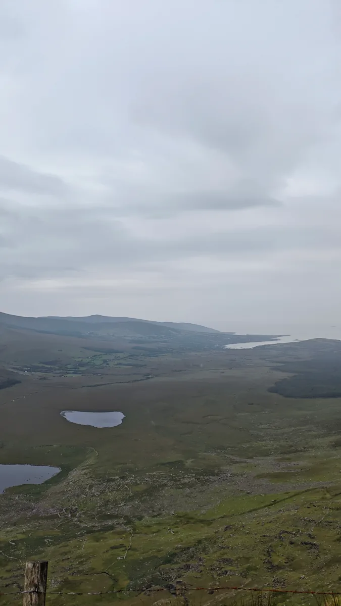
The scenery changes quickly once you leave the valley floor. On the north side, the road runs above a broad glacial valley with small lakes, boulder-strewn moraines and steep, rocky slopes. From the area around Peddler’s Lake you can see the rock lip of the corrie, a moraine-dammed lake and a kettle-hole lake in the valley below.
From the summit on a clear day, the views open up in both directions: south across Dingle Bay towards the Iveragh Peninsula and, out at sea, the Skellig Rocks; north towards Kerry Head and Loop Head in County Clare. In very clear weather you may even pick out the Aran Islands. It was a bit rainy when we stopped at the summit car park, and in weather like that the long-distance views are the first thing to go. The valley below is still worth the stop.


Conor Pass Parking and Photo Stops
There are two main places to stop on the pass. At the summit there is a small car park with views over the mountains, and on the north side there is the lay-by at the Conor Pass Waterfall, below Peddler’s Lake. We stopped at both: the waterfall lay-by on the way up and the summit car park at the top, where, unfortunately, it was a bit rainy at that moment.
Between these stops, the passing bays are there for traffic, not for photos. Stopping in one blocks the only place where two cars can get past each other, so please keep them clear. Neither stop has toilets, bins or a café, and on sunny summer days both can fill up quickly.
Both are classic tourist car parks where vehicles sit empty while everyone is out taking photos, so don’t leave any valuables in sight. When we leave our vehicle parked, we fit this KRASER steering wheel lock as an extra, visible deterrent. We also use the Wolfbox G900 Pro, which records both to the front and to the rear. On the road it works as our dashcam, which is reassuring on a narrow mountain road like the Conor Pass, and at car parks like these we switch on its parking monitoring.
These are Amazon affiliate links. As an Amazon Associate we earn from qualifying purchases, at no extra cost to you.
Can You Drive the Conor Pass in a Campervan?
This is the most important practical question for anyone travelling in a van or motorhome, and the answer depends on your vehicle’s size and weight, not on what it is called.
According to the Dingle Peninsula tourism site, the Conor Pass has length (max. 7.2 m) and weight (max. 2 tonnes) restrictions, and vehicles over 2 tonnes are not permitted on the stretch north-east of the summit car park, the side towards Cloghane, Castlegregory and Camp. The same site says coaches, caravans, campervans and trucks cannot use the pass, and that the route is not suitable for HGVs. Wikipedia also states that vehicles over two tonnes are prohibited. Kerry County Council has signs at both ends of the pass and at the junctions at Camp and Cloghane advising that the road is not suitable for HGVs and large vehicles (Radio Kerry, 2022). Large vehicles have got stuck on the pass in the past, sometimes after following sat-nav directions.
We could not find an official Kerry County Council page that sets out the exact legal wording of these limits, for example whether the 2 tonnes refers to unladen or gross weight. So treat the figures above as the best current information, follow the road signs on the day, and check your vehicle’s documents before you plan the route.
Every vehicle is different, so check your own vehicle’s figures rather than relying on anyone else’s experience of the road. A small car and a coachbuilt motorhome are very different on a road like this, both in width and weight. If you are in a larger van, a motorhome or towing a caravan, take the N86 between Dingle and the north side of the peninsula instead.
Weather and the Best Time to Drive the Conor Pass
Weather decides what kind of Conor Pass you get. In rain, fog or low cloud the views disappear and you literally drive up into the clouds, so use your fog lights in poor visibility. Wet weather has one upside: after heavy rain, water pours down the mountainsides in streams and small waterfalls. Wind can be strong on the exposed sections, and it is always a few degrees cooler at the top, so bring a warm layer.
The road is usually open all year, but in winter it can be closed if snow has not been cleared (castlegregory.ie). For the best views and the least traffic, aim for a clear day and drive early in the day or outside the summer holiday peak. There is no guarantee of clear skies on the Dingle Peninsula, so if the summit is in cloud, it can be worth waiting a little or coming back another day if your plans allow.
Conor Pass Waterfall and Peddler’s Lake
On the north side of the pass, a small waterfall comes down the rocks right beside the road, and above it sits Peddler’s Lake, a glacial corrie lake. This was our main stop on the drive. The waterfall is right next to the lay-by, while getting up to the lake means a short scramble over rocks, and the view over the lake was our highlight of the whole pass. If you want to stop here, read our guide to the Conor Pass Waterfall and Peddler’s Lake first, with parking, the walk up to the lake and what to wear.
Is the Conor Pass Worth Driving?
For us, yes. The Conor Pass turns the trip between Brandon Bay and Dingle into one of the most scenic drives on the peninsula, and the stop at the waterfall and Peddler’s Lake made it more than just a way to get from A to B.
It suits you if you are in a car or a small van within the limits, you are comfortable on narrow roads, and you have time to stop rather than rush. It is less enjoyable if you are nervous about reversing or meeting traffic on single-lane stretches, if the whole route is in cloud, or if you are short on time in peak season. And if your vehicle is over the weight or length limits, it is simply not an option: the N86 is the sensible choice.
Practical Tips for Driving the Conor Pass
- Check your vehicle first. Weight (2 tonnes) and length (7.2 m) limits are listed for the pass. If in doubt, take the N86.
- Do not trust the sat-nav blindly. Navigation apps may route you over the pass even in a large vehicle.
- Keep passing bays clear. Use them for letting traffic past, not for parking.
- Drive slowly and look ahead. Spot oncoming cars early and pull in at wider sections.
- Check the weather. Low cloud means no views; use fog lights in poor visibility.
- Plan your stops. The summit car park and the waterfall lay-by are the two places to stop.
- Bring a warm layer. It is cooler and often windier at the top.
- Don’t leave valuables in sight. Both stops are classic tourist car parks.
Our Conor Pass drive on video
Over the narrow pass towards Dingle – here’s how the drive looked from the road.
Driving the Conor Pass: 🎥 Narrow road and van tips – watch from 06:54.
Or watch the full video of our day on the Dingle Peninsula: the intro, Fermoyle Beach, Conor Pass Waterfall and Peddler’s Lake, Coumeenoole Beach, Clogher Head and Dingle Town. After the pass we headed west to Coumeenoole Beach on the Slea Head Drive.

Conor Pass FAQ
Where is the Conor Pass?
The Conor Pass is on the R560 on the Dingle Peninsula in County Kerry, Ireland. It links Dingle town in the south with Kilmore Cross in the north, where roads lead to Cloghane, Brandon and Castlegregory.
Is the Conor Pass difficult to drive?
It is narrow and twisty, with single-lane sections where one car has to pull into a passing bay or reverse. We met oncoming traffic, but it only got tight in one place and we didn’t find the drive difficult. Driven slowly and carefully, it is manageable, but it is not a relaxing road if you dislike tight bends or meeting oncoming traffic.
Which way is best to drive the Conor Pass?
Both directions are scenic. In a vehicle over 2 tonnes, though, only the Dingle side up to the summit car park is open to you; the stretch north-east of the summit towards Cloghane and Castlegregory is listed as not permitted for vehicles over 2 tonnes.
Where can you stop on the Conor Pass?
There is a small car park at the summit and a lay-by at the Conor Pass Waterfall on the north side. Passing bays are for traffic only, so don’t stop in them for photos.
Can you drive the Conor Pass in bad weather?
The road is usually open in rain and fog, but the views disappear and visibility can be poor, so drive slowly and use fog lights. In winter it can be closed when snow has not been cleared.
What is the alternative to the Conor Pass?
If your vehicle is too big or heavy, or you prefer an easier drive, use the N86 between Dingle and the north side of the Dingle Peninsula instead of the R560 over the pass.
Where We Went Next
From Dingle we headed west along the Slea Head Drive, stopped for lunch in Ventry and then drove the narrow road out to Coumeenoole Beach, a small cove below dramatic cliffs at the tip of the peninsula.
Plan your own trip
What we used on our Ireland road trip
📶 Mobile data
We used a local Three SIM — an eSIM is the easiest alternative if you want data from the moment you land. Get an Ireland eSIM from Airalo
🚁 Our drone
Most of our aerial shots were filmed with the Potensic Atom 2. Check the current price on Amazon
Some of these are affiliate links. If you book or buy through them, we may earn a small commission at no extra cost to you. It helps us keep the road trip — and this blog — going.
Watch the road trip
See Ireland from the driver's seat
Follow our family road trips on YouTube — the drives, the detours and the moments between the stops.
Subscribe on YouTubeOur Ireland road trip, stop by stop
← Related stop: Conor Pass Waterfall & Peddler’s Lake
← Earlier that day: Fermoyle Beach, Brandon Bay
Next stop → Coumeenoole Beach, cliffs on the Slea Head Drive
⛴️ Planning your own trip over? Here’s how our 24-hour ferry from Dunkirk to Rosslare went.
🗺️ See every stop on our interactive Ireland road trip map.
Planning your own Kerry road trip? Check our Fermoyle Beach guide, our Killimer–Tarbert ferry post, our Coumeenoole Beach post and our Ireland facts before you go.